
Westeros Map and Essos - Game of Thrones Modern Maps
Are you ready to traverse the legendary lands of Westeros and Essos, where the saga of ice and fire unfolds?
If you're a true "Game of Thrones" aficionado, the intricate details of these realms are not just backdrops but pivotal to the epic narrative. But have you ever wondered how the strategic placement of Dragonstone influences the quest for the Iron Throne, or the exact journey the Starks must undertake from Winterfell to Castle Black?
Our modern version of the map of Westeros and Essos will decode these mysteries for you. Embark on a cartographic adventure that brings George R.R. Martin's world to life, right down to the last holdfast.
Buy the maps!
 |
 |
Westeros Only |
Westeros + Essos |
Maps of Famous Locations and Cities in Game of Thrones
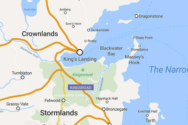
King's Landing: The Heart of Westeros Map
King's Landing, the bustling capital of the Seven Kingdoms, is more than just a city—it's the beating heart of Westeros. Surprisingly accessible from Dragonstone, this proximity is not just a convenience but a strategic asset for those with eyes on the coveted Iron Throne. Imagine the Targaryen kings of old, looking out towards the city, plotting their next move in the great game. Dragonstone itself is not just a mere island fortress; it's a treasure trove of history and lore, now more alive than ever with the highly anticipated spin-off, "House of the Dragon."
Exploring Braavos and Nearby Cities with details
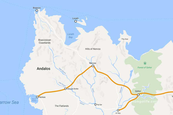
Andalos is situated on the western coast of Essos and holds historical significance as the original homeland of the Andals before their migration to Westeros. This region is rich in history and culture, with lush landscapes that once nurtured the Andal civilization.
To the north of Andalos, you'll find Braavos, the wealthiest and perhaps most enigmatic of the Free Cities, famous for its Titan statue and its Iron Bank. If you're exploring the map further, you'll also come across other Free Cities like Lorath, known for its intricate mazes; Pentos, famous for its grand harbor; Norvos, distinguished by its religious zeal; and Qohor, renowned for its skilled blacksmiths who can reforge Valyrian steel.
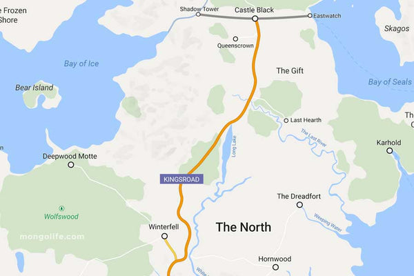
Winterfell: The Northern Star in Westeros Maps
On a offshoot from the Kingsroad, you'll find Winterfell, home the Starks, lead by Ned Stark, the Warden of the North, and the gateway to the Lands of Ice. Continue north to reach Castle Black at The Wall. Even further north you'll find the Others, also known as white walkers, cold gods and more.
To the west you'll find Bear Island, home to House Mormont (Lyanna and Ser Jorah) and Deepwood Motte, home to House Glover. To the east is The Dreadfort, the stronghold of Ramsay Bolton & Co as well as Karhold, home of the Karstarks.
Qarth and the Rich Cities of Essos on a Game of Thrones Map
One of the great trading cities of Essos is Qarth, located in the eastern parts of the continent. Nestled between forbidding mountain ranges and the Jade Sea, Qarth is often referred to as "the Queen of Cities." It's not just a hub for merchants, but also a crossroads of culture and a melting pot of traditions.
Rich in both resources and intrigue, the city is a must-see destination for explorers in the Game of Thrones world. Its towering walls and intricate gates hold mysteries and treasures that have lured many, from Daenerys Targaryen to an array of fortune seekers.

Bay of Dragons: A Place of Fire
Formerly known as Slaver's Bay, this was the area where Daenarys liberated the slaves from their masters. The most known and most powerful city is Meereen in the north, famous for its pyramids and previous base of Miss Targaryen.
A bit further south is Yunkai, whose main export are bedslaves and furthest south is Astapor, where Dany freed and acquired the Unsullied.

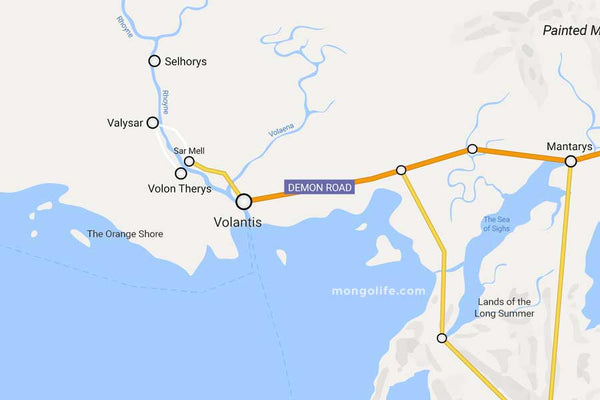
Volantis in Essos Maps
The first of the Free Cities lies on the southern coast of Essos where the Rhoyne meets the Summer Sea. Founded by the Valyrian Freehold, this ancient city stands as a testament to the far-reaching influence of Valyria's once-mighty empire. Over time, it has developed a distinct identity, merging Valyrian roots with a myriad of local customs and practices.
Known for its bustling ports and rich tapestry of cultures, the city has become a cornerstone of trade, politics, and innovation in Essos. Its strategic location near the confluence of major waterways makes it a linchpin for regional commerce, while its storied history adds layers of complexity and fascination for any Game of Thrones fan.
Iron Islands: The Maritime Masters of GoT
Home of the Greyjoys, the Iron Islands are a rugged archipelago off the western coast of Westeros. Pyke serves as both the name of the main island and the formidable castle where the Greyjoy family reigns.
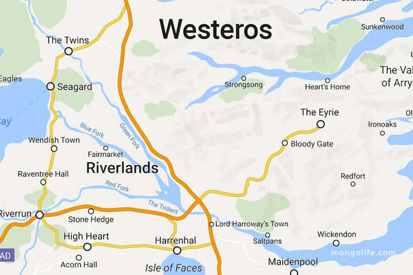
Known for their seafaring skills and martial culture, these islands are a hub of naval power. To the east of the Iron Islands, you can find significant landmarks like The Twins, a crucial crossing point over the Green Fork, and Riverrun, the ancestral seat of House Tully
The Eyrie: Exploring the Heights
To get to The Eyrie and see the moon door you have to pass through the Bloody Gate. Famous home to House Arryn. Another famous spot is Harrenhal, the largest castle in Westeros.
This is for example where Arya, Gendry and Hot Pie were taken prisoners. Again here you can find The Twins, home to House Frey and the Red Wedding.
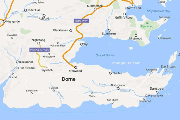
Dorne: The Southernmost Kingdom in Game of Thrones Maps
In the southernmost part of Westeros lies Dorne, the kingdom that is home to the Dornish. On the eastern side you'll find Sunspear, home to House Martell.
In the west is Blackmont, a holdfast and home of House Blackmont. You can also spot Highgarden, home of House Tyrell and the capital of the Reach.
Casterly Rock: The Lannister Stronghold on the map
The ancestral stronghold of House Lannister is Casterly Rock. A major gold mine is located right under it and provides the Lannisters with their wealth. The main city of the region is Lannisport. Close by is Clegane's Keep, and you guessed it, home of House Clegane.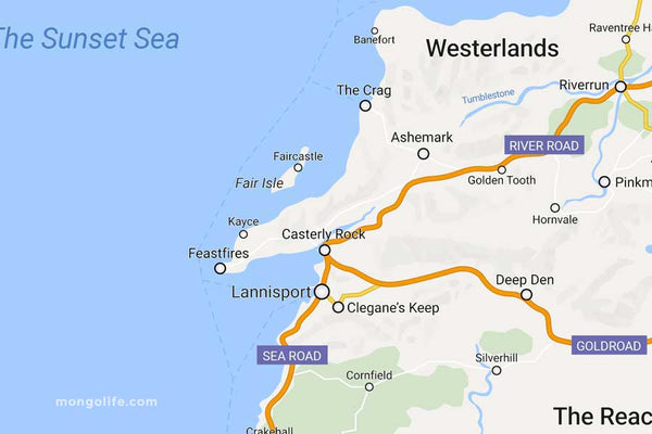
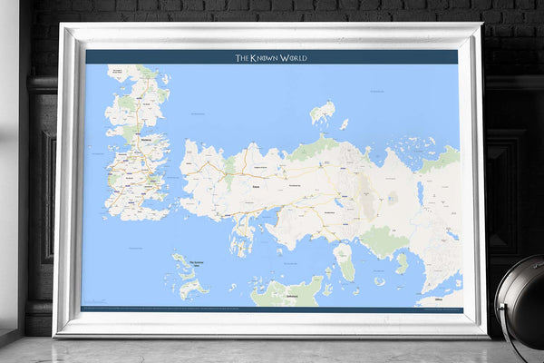
Don't Just Be a Fan, Own the World—Literally!
🌍 Step into the realms of Westeros, Essos, and beyond with our exclusive map posters. Perfect for both Game of Thrones aficionados and geography buffs, these Google Maps looking high-quality prints will make your walls a topic of conversation. Available in many formats to help you find your frame size.
✅ From the treacherous terrains of Westeros to the magical lands of Middle-Earth—unlock the secrets of your favorite worlds now!
👉 Unveil Your Next Adventure: SHOP EXCLUSIVE MAP POSTERS NOW! ≫
SHOP FUNNY T-SHIRTS


I Fucking Love Losing Money - T-Shirt
Original price
$30.00
-
Original price
$30.00
Original price
$30.00
$30.00
-
$30.00
Current price
$30.00
I Fucking Love Losing Money - Funny Gambling & Poker T-Shirt If you're the kind of degenerate who keeps hitting on 16 or betting the rent money...
View full details
Original price
$30.00
-
Original price
$30.00
Original price
$30.00
$30.00
-
$30.00
Current price
$30.00


Pound My Cake Daddy - T-Shirt
Original price
$30.00
-
Original price
$30.00
Original price
$30.00
$30.00
-
$30.00
Current price
$30.00
🍰 Serve Up Sass, Slice That Cake Slap on this tee and let the jokes fly—“Pound My Cake Daddy” is a no‑holds‑barred gag shirt built for bold laughs....
View full details
Original price
$30.00
-
Original price
$30.00
Original price
$30.00
$30.00
-
$30.00
Current price
$30.00


Mouths Don't Get Pregnant - T-Shirt
Original price
$30.00
-
Original price
$30.00
Original price
$30.00
$30.00
-
$30.00
Current price
$30.00
💋 Mouths Don’t Get Pregnant – T-Shirt Subtle? Not really. Accurate? Technically. This “Mouths Don’t Get Pregnant” t-shirt is the perfect storm of i...
View full details
Original price
$30.00
-
Original price
$30.00
Original price
$30.00
$30.00
-
$30.00
Current price
$30.00


Ask Me About My Mystery Discharge - T-Shirt
Original price
$30.00
-
Original price
$30.00
Original price
$30.00
$30.00
-
$30.00
Current price
$30.00
🎤 Ask Me About My Mystery Discharge Tee When your mystery is too juicy not to share. This shirt dares strangers to ask about your mystery discharge...
View full details
Original price
$30.00
-
Original price
$30.00
Original price
$30.00
$30.00
-
$30.00
Current price
$30.00


Ronnie Pickering's Boxing Club - T-Shirt
Original price
$30.00
-
Original price
$30.00
Original price
$30.00
$30.00
-
$30.00
Current price
$30.00
🥊 Ronnie Pickering’s Boxing Club Tee Join the legend. This tee pays tribute to the viral icon Ronnie Pickering, immortalized for shouting “Do you k...
View full details
Original price
$30.00
-
Original price
$30.00
Original price
$30.00
$30.00
-
$30.00
Current price
$30.00


The F-caw-f Crow - T-Shirt
Original price
$30.00
-
Original price
$30.00
Original price
$30.00
$30.00
-
$30.00
Current price
$30.00
F‑caw‑f Crow Tee Let the bird do the talking. The f‑caw‑f crow shirt delivers a darkly witty pun. Perfect for when you want to tell people to fuck ...
View full details
Original price
$30.00
-
Original price
$30.00
Original price
$30.00
$30.00
-
$30.00
Current price
$30.00
Leave a comment